
Marion Neighbors by Public Source
A block lookup works best when each source has one job. Linn GIS establishes parcel shapes and boundaries. The assessor adds owner and mailing context. Recorder records document transfers, while Marion permits and planning applications date public work tied to an address. Historical reverse directories show past listings. Iowa voter data has strict access and use limits and is not an open street roster.
| Source | What It Shows About a Block | Access |
|---|---|---|
| Linn GIS parcel map and REST | Adjacent shapes, GPNs, situs ZIPs, legal descriptions and overlays | Free map and data service |
| Linn Assessor | Deed or contract owner, values and mailing versus situs context | Free address or parcel form |
| Iowa voter list | Registration address, precinct, status and permitted participation fields | Paid request with intended-use limits |
| Marion permits and planning | Service-address work, applications, plats and public hearings | Tyler portal and city records |
| Historical reverse directory | Past occupants or subscribers, phone, work and spouse clues | Marion digital archive |
An owner is not necessarily an occupant. Tax mail may go to an estate, trust, business, representative, or another city. A reverse-directory name may be a subscriber, business, or former occupant. State the narrow result, such as “parcel owner” or “1996 directory listing,” and include the date. That keeps a useful Marion neighbors search from becoming an unsupported claim about a current household.
Linn GIS Around Marion Neighbors
The Linn GIS planning map service exposes parcel, subdivision, corporate-limit, zoning, flood, and other boundary layers. The map supports pan, zoom, selection, and parcel geometry. Its REST service also supports spatial queries. Research did not verify a named radius or buffer button, so use visible adjacent parcel shapes rather than promising an automated radius search.
The official map-service page below shows the layers behind a block inspection.
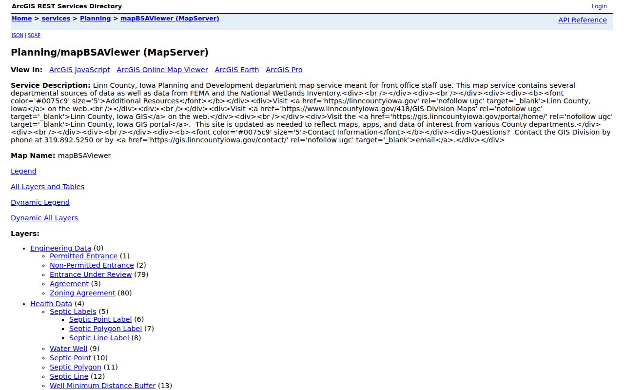
Check Corporate Limit, Incorporated Area, and Situs City before calling a parcel part of Marion. County GIS data also carries an accuracy warning, so plats and held records control a disputed boundary.
Map a Marion Neighbors Block
Start with one known address and move only to parcels that visibly touch or face it. Save the target GPN before selecting its neighbors. The GPN is the county parcel key; it links map geometry to assessor and recorder records. Preserve only the identifiers needed for the question instead of copying every owner name on the block.
- Locate the address in the Linn Land Records Map and select its parcel.
- Record the GPN, situs address, legal description, and current boundary shape.
- Pan around it and select adjacent shapes one at a time.
- Open assessor links to separate owner, mailing address, and physical situs.
- Use recorder references only when a transfer question calls for them.
This flow answers an immediate block question. For every parcel along the full road, switch to the Marion directory by street, which owns the longer street-by-street chain. A matching mailing address can support an inference about owner occupancy, but it still does not name every person inside.
Marion's Twelve Planning Areas
Marion's 2010 community-planning material names twelve areas: Uptown Marion, Southeast Marion, Indian Creek, 29th Avenue, Hunters Ridge, Lowe Park, Northwest Growth Area, Boyson Trail, Thomas Park, South Conservation Area, Southeast Growth Area, and Northeast Growth Area. These labels help place a block within development and civic records. They are not all legal neighborhood boundaries or proof of an association.
Use a planning-area name to search council packets, zoning files, plats, park records, or public projects. Then return to the parcel layer for exact geography. This matters near growth areas and corporate limits, where a familiar neighborhood term can extend beyond the city line.
Note: A Marion planning label is a research aid, not a verified HOA boundary or household directory.
Marion Neighbors in Civic Records
Official community records document public service without exposing private member rolls. Marion boards and commissions include Historic Preservation, Planning and Zoning, Public Works, Traffic, Tree, Stormwater, Park Board, Civil Rights, Library Board, and bicycle and pedestrian bodies. Meeting packets may connect a person to a public comment, appointment, application, or project. They do not establish a current address unless the record says so.
Friends of Marion Parks
Official group page
Began in 2002; meets monthly from April through October and supports a neighborhood park initiative.
Marion Public Library
Library resources
Local archive and licensed history tools; access varies by card, residency, or in-library use.
Heritage Center
Research resources
Historical photographs, maps, newspapers, and genealogy help by appointment.
No verified public Marion HOA, block-watch, congregation, club, or complete Chamber member directory was located. Ask for public contacts, meeting records, or historical newsletters, not private membership names.
Marion Block Voter Boundaries
Iowa's public voter lookup does not return a roster for a street. A county voter-list request can include registration and mailing addresses, precinct name or code, active status, party or request options, and selected participation history under the statutory-use form. It cannot show ballot choices, and protected voters must not be disclosed.
Safe at Home participants may use a substitute address and confidential voting process. The program protects qualifying survivors and should never be bypassed through guesses drawn from parcels or social data. Treat voter material as a restricted civic record, not a shortcut for listing Marion neighbors.
Marion Activity by Address
The Marion Tyler permit portal covers 2010 forward, while Building Services handles older requests. A service-address search can show a project, applicant or contractor context, inspections, and final status. Planning files may add plats, rezoning, variance, or annexation applications. These are records of public work and review, not proof of all occupants.
City infrastructure GIS adds sewer, stormwater, trees, traffic, sidewalks, and subdivision context without exposing customer accounts. Marion Resident Connect's incident map excludes names and exact addresses. Together, these sources explain what has happened near a block while preserving the line between civic transparency and a private household roster.
Compare Marion Neighbor Sources
Official sources identify their custodian, date, and record type. Commercial neighbor tools often merge public property data, old directories, marketing files, and purchased datasets. Their output can be stale, mismatched, or costly, and no commercial service is authoritative.
| Source type | Strength | Limit |
|---|---|---|
| Official parcel and assessor records | Dated land and ownership fields | Not a household roster |
| City permits and public applications | Address-linked civic activity | Applicant may not be an occupant |
| Historical reverse directories | Past address listings by edition | Annual snapshot, not current proof |
| Commercial compilations | Broad merged search | Unknown refresh and matching methods |
For a sound Marion neighbors search, retain the official label and date. Confirm a claim in the custodian's system rather than repeating a commercial profile.
Historical Marion Neighbors by Address
Current parcel records answer a current land question. The Marion Digital Community History Archive supplies an address-first layer for older blocks. Its Marion City Directory run covers 1915 through 2009, and the scanned 1996 edition expressly includes a street guide or reverse section. The archive also lists a Marion Telephone Directory from 1927 through 1937 and a Marion Rural Directory from 1900 through 1947. Each edition is a dated snapshot, not proof of a continuous stay.
Begin with the street or reverse section for the target year. Record the house number, street suffix, apartment, telephone, spouse, work notation, and homeowner mark as printed. Then check the editions before and after it. A change can mark a move, but absence may also reflect a missed listing, a name filed under another household member, or a gap in the run. Search the same address in Marion Sentinel, Marion Register, or Marion Times pages for sales, legal notices, civic activity, and obituaries.
The 1950 federal census answers a different question. It groups people into an enumerated household and is subject to the federal 72-year release rule. Iowa's final state census was in 1925. Ward, township, street, and city-limit geography can differ across these sources, so compare maps and enumeration districts before treating two similar addresses as the same place.
This layered method also respects change on the block. Current GIS supplies today's parcel shape. A reverse directory supplies the listed address in one year. A census supplies a household in its census year. Keep all three dates visible, and Marion neighbors from different eras will not be mistaken for one another. Dates prevent false matches.
Privacy for Marion Neighbors
A block is not a public list of every household. Renters, children, roommates, visitors, utility customers, postal forwarding data, DMV addresses, and private membership rolls remain outside the lawful public chain. Safe at Home records, protected voter information, sealed court files, and other confidential records must remain protected.
The Iowa Consumer Data Protection Act gives qualifying consumers rights against covered businesses, but it does not create a universal deletion button for deeds, assessor parcels, court dockets, or historical newspapers. Record-specific corrections or redactions go to the custodian. If a commercial business misuses data, the Iowa Attorney General offers a complaint route.
Lawful use. Search Marion neighbors for civic curiosity, reconnection, or personal safety awareness. Never watch, harass, intimidate, or expose another person.